Categories
Shopping cart (0 items € 0)
Advanced search

Middle East & Islamic World / Cartography & Exploration

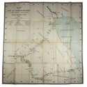
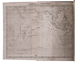
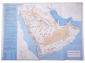
One of the earliest maps of Arabia, with unique contemporary illumination

[MAP - ARABIAN PENINSULA]. PTOLEMAEUS, Claudius. [Jacobus ANGELUS, trans.; Nicolaus GERMANUS, ed.]. Sexta Asie Tabula.
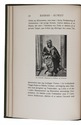
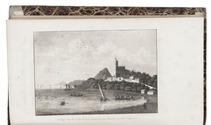
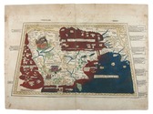
Ulm, Lienhart Holle, 1482. Oblong 1mo (whole sheet: 41.5 by 57 cm). With a double-page woodcut map. Finely coloured by a contemporary hand, with near-contemporary manuscript vignette illustrations of an Ababeel bird, Makkah (Mecca) and the Kaaba in pen and wash highlighted in gold. Full description
€ 150,000
Order Inquire Terms of sale

A Danish traveller in Kuwait, Saudi-Arabia and Bahrain, meets Mubarak al-Sabah and Ibn Saud, presentation copy

RAUNKIAER, Barclay. Gennem Wahhabiternes land paa kamelryg. Beretning om den af det Kongelige Danske Geografiske Selskab planlagte og bekosterde forskningsrejse i Ost- og Centralarabien 1912.
Copenhagen, Gyldendalske boghandel, Nordisk forlag, 1913. 8vo. With a frontispiece showing the author in Arab garb, 88 illustrations in text, most of them reproductions of drawings and photographs by the author, and a folding map loosely inserted in a pocket at the end. Publisher's green cloth. [1], [1 blank], [2], 304 pp. Full description
€ 5,000
Order Inquire Terms of sale

Stunning double-tinted views of the Middle East, after drawings made in 1838 and 1839,
with 250 plates

ROBERTS, David, George CROLY and William BROCKEDON. The Holy Land, Syria, Idumea, Arabia, Egypt & Nubia.
London, Day & son (vol. 3: New York, D. Appleton & Co.), 1855-1856. 6 volumes bound as 3. Imperial 8vo (30 x 22 cm). With 250 numbered plates (including 6 tinted lithographed title-pages, 2 stone-engraved maps and 239 tinted and double-tinted lithographed and 2 chromolithographed views). Contemporary, richly gold-tooled reddish-brown morocco, gold-tooled turn-ins, marbled endpapers, gilt and gauffered edges. With thin paper guard leaves facing each plate. Full description
€ 18,000
Order Inquire Terms of sale

A compendium for sailing the Indian Ocean, with three charts, second copy located

ROSSER, William Henry. Short notes on the winds, weather, & currents, together with general sailing directions and remarks on making passages; to accompany a chart of the Indian Ocean. With two[=three] illustrations.
London, James Imray and son, 1866. 8vo. With 3 folding lithographed charts (the first as frontispiece and the third possibly extra added). Modern brown cloth, spine with a long vertical leather title-label. [4], 64 pp. Full description
€ 3,500
Order Inquire Terms of sale

Unique copy in a sumptous Viennese binding

RUDOLF, Archduke of Austria and Hungary. Voyage en Orient. Traduit de lAllemand. Illustrations daprès les dessins originaux de Franz von Pausinger.
Vienna, Imprimerie Imperiale et Royale de la Cour et de lÉtat, 1885. Folio. With 37 etched plates.Contemporary calf, richly gold-tooled front board, spine label, gilt edges. [8], 168, [2] pp. Full description
€ 9,500
Order Inquire Terms of sale

Road map of Saudi Arabia, with plans of Jeddah, Riyadh and Dammam

[SAUDI ARABIA – MAP]. Road map of Saudi Arabia: accurate and most up to date road map.
[Saudi Arabia, 1960s]. Colour-printed folding map (48 x 69.5 cm) of the Arabian peninsula (scale: ca. 1: 5,000,000), with on the back a city map of Jeddah, a plan of the main business quarter of Riyadh, a city plan of Dammam(?), a distance table and 8 photographic city views. Full description
€ 1,800
Order Inquire Terms of sale

Road map of Saudi Arabia, with plans of Jeddah, Riyadh and Dammam

[SAUDI ARABIA – MAP]. Road map of Saudi Arabia: accurate and most up to date road map.
Karachi, Pakistan, printed at Golden block works, [1970s]. Colour-printed folding map (48 x 69.5 cm) of the Arabian peninsula (scale: ca. 1:5,000,000), with on the back a city map of Jeddah, a plan of the main business quarter of Riyadh, a city plan of Dammam(?), a distance table and 8 photographic city views. Full description
€ 1,750
Order Inquire Terms of sale

Rare collection of travel accounts, with 12 aquatint views

SOMMER, Johann Gottfried. Merkwaardige bijzonderheden, inhoudende de nieuwste ontdekkingen in de natuurkunde, natuurlijke historie, land- en volkenkunde, op alle gedeelten van den aardbol.
Amsterdam, Ten Brink and De Vries, 1825-1827. 4 volumes. 8vo. With 4 engraved title-pages, each with one of two aquatint views, plus 10 aquatint views on 8 plates, all by H.W. Hoogkamp. Contemporary half calf, gold-tooled spine. VIII, 331, [1 blank]; IV, 316; [IV], 316; [IV], 312 pp. Full description
€ 1,500
Order Inquire Terms of sale
101 books found / Show all