Categories
Shopping cart (0 items € 0)
Advanced search

Middle East & Islamic World / Cartography & Exploration

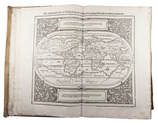
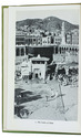
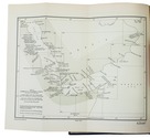
First complete edition of Cosmas's Christiana topographia describing his travels
in the Red Sea and the Arabian Gulf

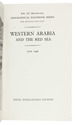
MONTFAUCON, Bernard de (editor). Collectio nova patrum et scriptorum Graecorum, Eusebii Caesariensis, Athanasii, & Cosmae Aegyptii.
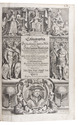
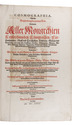
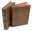
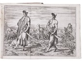
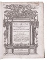
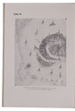
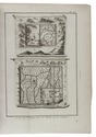
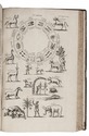
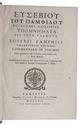
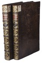
Paris, Claudius Rigaud, 1707. 2 volumes. Folio. With 4 engraved plates, and 3 woodcut illustrations in the text. Each volume with an engraved headpiece, the first incorporating the coat of arms of Pope Clement XI, and the second that of Jean-Paul Bignon. Contemporary calf, richly gold-tooled spine and binding edges. [14], XL, [1], [1 blank], 732, [26], [2 blank]; [16], LXVIII, 112, [2], I-XXIV, 113-593, [26], [1 blank] pp. Full description
€ 25,000
Order Inquire Terms of sale

Most extensive edition of a monumental, extensively illustrated description of the world

MÜNSTER, Sebastian. Cosmographia, das ist: Beschreibung der gantzen Welt, ...
Basel, heirs of Sebastian Henricpetri, 1628. Folio (38 x 24.5 cm). With engraved title-page, letterpress title-page printed in red and black with woodcut portrait of Münster on the back, 26 numbered double-page woodcut maps on inserted bifolia, 72 double-page woodcut maps, plans and views on integral leaves, and about 1500 woodcut illustrations in the text (including repeats) showing maps, plans, views, plants, animals, monsters, etc. Contemporary vellum. [24], “1752” [=1748] , [12] pp. Full description
€ 48,000
Order Inquire Terms of sale

Handbook to western Arabia, intended for British naval officers only

NAVAL INTELLIGENCE DIVISION, [SCOTT, Hugh, a.o.]. Western Arabia and the Red Sea, B.R. 527 (restricted) geographical handbook series for official use only.
(Colophon: Oxford, University press), Naval Intelligence division, 1946. 8vo. With 357 reproductions of photographs on 90 plates, numerous (folding) maps and illustrations in text and 1 separate folding map. Original publisher's green cloth. XIX, [1 blank], 659, [1 blank] pp. Full description
€ 600
Order Inquire Terms of sale

Navigating the Red Sea and Gulf of Aden

[NAVIGATION - RED SEA]. Red Sea and Gulf of Aden pilot comprising the Suez canal, the gulfs of Suez and 'Aqaba, the Red Sea, the Gulf of Aden, ...
Including: Supplement no. 1-1957 relating to the Red Sea and Gulf of Aden pilot, tenth edition ...
London, published by the Hydrographic Department, Admiralty, 1955-1957. 8vo. With a folding map (printed on both sides), 2 coloured plates with diagrams (printed on both sides), 28 plates showing coastlines and occasionally a map (many printed on both sides), and many some illustrations in text. Original blue cloth; supplement with original printed paper wrappers. LI, [1 blank], 518, [1], [1 blank] pp. Full description
€ 1,750
Order Inquire Terms of sale

Important contribution to the study of the Middle East

NIEBUHR, Carsten. Voyage en Arabie & en d'autres pays circonvoisins. Tome premier[- second]. Traduit de l'Allemand.
Amsterdam, Steven Jacobus Baalde; Utrecht, Barthelemy Wild (colophon: printed by Joh. Jos. Besseling, Utrecht, 1775), 1775-1780. 2 volumes. 4to. With 2 engraved integral title-pages, 124 engraved plates (many folding) and a folding map of Yemen (in partial colour). Contemporary gold-tooled calf. VIII, [6], 409, [1], [1 blank]; VI, [10], 389, [1] pp. Full description
€ 6,000
Order Inquire Terms of sale

Rare travel account

OPPENHEIM, Max von. Vom Mittelmeer zum Persischen Golf durch den Hauran, die Syrische Wüste und Mesopotamien.
Berlin, Dietrich Reimer, 1899-1900. 2 volumes. Large 8vo. With 2 (of 3) folding maps in pockets on the inside of the back board and numerous illustrations in the text and on photographic plates. Original illustrated green cloth. XV, [1], 334; [1], 434 pp. Full description
€ 8,500
Order Inquire Terms of sale

One of the earliest sources on the Congo and central Africa, complete with all plates and maps

PIGAFETTA, Filippo and Duarte LOPEZ. Relatione del reame di Congo et delle circonvicine contrade tratta dalli scritti & ragionamenti di Odoardo Lopez.
Rome, Bartolomeo Grassi, [1591]. 4to. With an integral engraved architectural title-page (with the coat of arms of the dedicatee Antonio Migliore, Bishop of San Marco), large folding engraved general map of Africa (64×44 cm), large folding engraved map of the Congo (43.5×51.5 cm) and 8 numbered folding engraved plates of plants, animals and inhabitants of the country, by Natalis Bonifazio. Contemporary limp sheepskin parchment. [8], 82, [1], [1 blank] pp. Full description
€ 60,000
Order Inquire Terms of sale

Only published edition of the original 1521 text of the navigation book of the great Ottoman admiral

PIRI REIS (Paul KAHLE, ed.). Bahrije. Das türkische Segelhandbuch für das Mittelländische Meer vom Jahre 1521.
Berlin and Leipzig, Walter de Gruyter & Co., 1926-1927. 3 volumes. Large 8vo (26 x 18 cm). Volume 1 with 137 reproductions of manuscript pages of Ottoman Turkish text and maps and volume 2 with 4 plates. Publisher's original printed wrappers. [1], [1 blank], [2] pp. + 64 ll. + [4], [1 blank], [1] pp.; ll. 65-137; [1], [1 blank], XLVIII, 88 pp. Full description
€ 2,500
Order Inquire Terms of sale

Augmented Dutch edition of Pocockes celebrated description of the Near and Middle East,
with 205 engraved plates

POCOCKE, Richard. Beschryving van het Oosten, en van eenige andere landen, ...
Utrecht, Gijsbert Tieme and Abraham van Paddenburg; Rotterdam, Jacobus Bosch and Reinier Arrenberg; Amsterdam, Martinus de Bruyn, 1776-1786. 3 volumes (in 6 parts) bound as 6. 4to. With 205 engraved folding plates (irregularly numbered I-CIII), including maps, plans, views and other illustrations, depicting temples, antiquities, plants, animals, etc. Contemporary half calf. XXXVI, 219, [1 blank], [11], 224-491, [1 blank]; [12], 262, [2 blank], VIII, [3], 268-376, 397-519, [1 blank]; VIII, 262, [2 blank], VIII, [3], 268-403, [1 blank]; [4], 115, [1], 124 pp. Full description
€ 15,000
Order Inquire Terms of sale

Important survey of ancient Egyptian and Nubian sites now submerged, with a very large and detailed map: a fine copy, partly unopened

PROKESCH, Anton, Ritter von Osten. Das Land zwischen den Katarakten des Nil. Mit einer Karte, ...
Vienna, Carl Gerold, 1831. 12mo (the book) and 17.5 x 25 cm (the folder with the folded map). With a separate large folding lithographed map (98 x 69 cm; image area 93 x 64 cm) assembled from 2 sheets, with the cultivated areas along the river hand-coloured in green as published, also showing 17 floor plans of temples and a plan of a Roman wall. The book in the publishers original light green paper wrappers and the map in a matching green paper folder. [8], 181, [3 blank] pp. plus folding table and separate map. Full description
€ 3,750
Order Inquire Terms of sale
101 books found / Show all