Categories
Shopping cart (0 items € 0)
Advanced search

Middle East & Islamic World / Cartography & Exploration

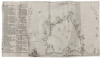
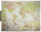
Large map depicting the world's oil industry, including the Middle East and Egypt

KORYTKO, Stefan. General orientative map of the world's oil industry | Übersichtskarte der Welt- Naphtha-Industrie | Carte d'orientation de l'industrie de pétrole du monde | Mapa pogladowa swiatowego przemyslu naftowego.
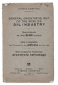
Lviv, Stefan Korytko, 1925. Large folding chromolithographed map (map size 65.5 x 88 cm). Original publisher's printed paper wrappers. Full description
€ 6,500
Order Inquire Terms of sale

Travels through the Middle East, India and Europe, with 34 woodcut illustrations, including several trees

LA BOULLAYE LE GOUZ, Francois de. Les voyages et observations du sieur de la Boullaye-le-Gouz gentil-homme Angevin...
Paris, Francois Clousier, 1653. 4to. With a woodcut and an engraved author's portrait, 34 woodcut illustrations in text, including several full-page, and some woodcut initals, head- and tailpieces. Contemporary calf, gold-tooled spine. [16], 540, [10], [2 blank] pp. Full description
€ 18,000
Order Inquire Terms of sale

French account of the Siege of Candia (Heraklion) in first edition with engraved fortification plan

[LA FEUILLADE, François Aubusson de]. Journal de l'expedition de Monsieur de la Feuillade, pour le secours de Candie. Par un volontaire.
Lyon, Jean Thioly, 1669. 12mo. With woodcut printer's device on title-page, some woodcut initials and head-and tailpieces and 1 engraved folding plan of the fortification of Candia (20 x 28.5 cm). Contemporary calf, gold-tooled spine and sprinkled edges. [8], 198, [2] pp. Full description
€ 4,750
Order Inquire Terms of sale

Around the world in 1180 days, with 2 folding maps and 31 steel-engraved views

LAPLACE, Cyrille Pierre Théodore. Campagne de circumnavigation de la frégate l'Artémise, pendant les annéees 1837, 1838, 1839 et 1840, ... Tome premier[-sixième].
Paris, Arthus Bertrand, 1841-1854. 6 volumes. 8vo. With 2 large folding engraved maps and 31 steel-engraved views. With the maps coloured in outline or partly coloured, and with the routes indicated and coloured. Contemporary boards, covered with the publisher's original green printed paper. XXXIX, [1 blank], 343, [1 blank], [3], [1 blank]; [3], [1 blank], 467, [1 blank], [3], [1 blank]; [3], [1 blank], 548, [1], [1 blank]; [3], [1 blank], 464, [3], [1 blank]; [3], [1 blank], III, [1 blank], 542, [2]; [3], [1 blank], 400 pp. Full description
€ 22,500
Order Inquire Terms of sale

Illustrated eye-witness accounts and tall tales: sixty years of a sailor's world travels

LE BLANC, Vincent. De vermaarde reizen van de heer Vincent Le Blanc van Marsilien, die hy sedert d'ouderdom van veertien jaren, tot aan die van zestig, in de vier delen des werrelts gedaan heeft ...
Amsterdam, Jan Hendricksz. Boom, Jan Rieuwertsz., 1654. 2 parts in 1 volume. 4to. With engraved title-page and 7 engraved plates. 19th-century boards. [1], [1 blank], 152, 116 pp. Full description
€ 4,500
Order Inquire Terms of sale

Journal of a 1674/75 overland voyage through India, Iran, Iraq and Syria to Amsterdam

LEEUWENSON, Joannes (Pieter Arend LEUPE, ed. & intro.). Eene overlandreis uit Indië naar Nederland, in 1674-1675.
[Amsterdam, Frederik Muller, 1863]. 8vo. Offprint, retaining the original pagination and collation, of an article in Bijdragen tot de Taal-, Land- en Volkenkunde van Nederlandsch-Indië, 6 (1863). 20th-century stiff paper wrappers, with a printed label on the front. pp. [89], 90-142. Full description
€ 1,250
Order Inquire Terms of sale

Wonderful account of the geography and development of Palestine and Syria during the Muslim rule

LE STRANGE, Guy. Palestine under the Moslems. A description of Syria and the Holy Land from A.D. 650 to 1500. Translated from the work of the mediaeval Arab geographers.
Boston and New York, Houghton, Mifflin and Company, The Riverside Press, Cambridge, 1975. Illustrations, maps, plans (some fold-out) throughout. Original cloth binding. XXII, [2], 604 pp. Full description
€ 650
Order Inquire Terms of sale

Detailed observations of life in the Ottoman Empire, Egypt
and elsewhere in the Levant and Middle East ca. 1610

LITHGOW, William. Willem Lithgouws 19 jaarige lant-reyse, uyt Schotlant nae de vermaerde deelen des werelts Europa, Asia en Africa.
Amsterdam, Jacob Benjamin (colophon: printed by Christoffel Cunradus), 1653. 2 parts in 1 volume. 4to. With engraved frontispiece by Crispijn de Passe, 1 engraved plate and 6 engraved illustrations in the text. 19th-century half vellum. [8], 186, 98 pp. Full description
€ 1,950
Order Inquire Terms of sale

Famous work on the Middle East, illustrated with very early photogravures of the Holy Land

LUYNES, Honoré d'Albert de. Voyage d'exploration à la mer Morte, à Petra et sur la rive gauche du Jourdain. ... Oeuvre posthume publiée par ses petit-fils sous la direction de M. le Comte de Vogüé.
Paris, Arthus Bertrand (on back of half-title: printed by E. Martinet (vols. 1-2) and Arnous de Rivière (vol. 3)), [1874]. 3 volumes of text and 1 atlas of plates. Imperial 4to (35.2 x 26.5 cm). With 14 numbered lithographed plates in volume 3 (4 double-page chromolithographed maps, views and geological sections; 2 further geological plates and 8 plates showing archaeological specimens), 85 plates in the atlas volume (including 65 photogravures and double-page chromolithographed maps) and numerous wood-engravings in the text. Set in roman and italic types with occasional passages in Greek and especially Arabic. Text volumes in original publisher's letterpress-printed light blue wrappers, atlas in half cloth portfolio with the original publisher's letterpress-printed paper sides, matching the text volumes; the 4 volumes preserved in 2 modern black half calf clamshell boxes. [8], 388; [6], 226; [4], VI, 326; [4] pp. Full description
€ 35,000
Order Inquire Terms of sale
101 books found / Show all